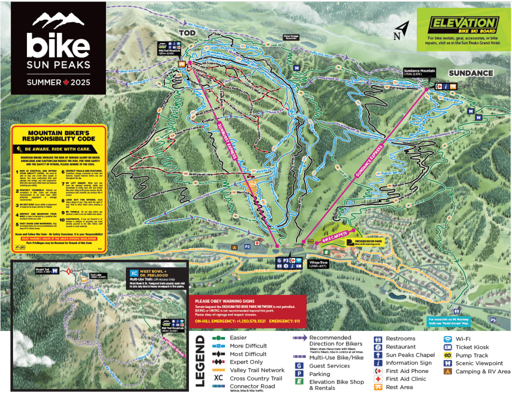
As the Sun Peaks Bike Park gears up for opening day June 14, updates to park maps will help guests navigate the trails. A freshly illustrated summer trail map is now complete, blending artistry with function and offering a better way to explore the park.
For years, the resort’s winter map featured the distinctive hand-painted style of James Niehues, a widely respected artist in the ski industry.
“With our winter mapping, we always worked with James Niehues, who was very widely regarded and well known for his hand-painted map style,” said Sun Peaks Resort LLP (SPR) marketing service manager, Lucie Renwick. “We had not done the same for our summer map and we were missing that continuity with that hand-painted style.”
When Niehues retired, the team began looking for an artist who could continue in the same tradition, finding Colorado-based illustrator Stefan Bast, who previously worked with SPR on the West Bowl inset map released during the 2024-25Morrisey winter season.
“The only key difference with Stefan is that he does digital hand painting; he creates all of his own kind of digital brushstrokes.”

While Bast uses a different technique from Niehues, the end result still captures the hand-painted style.
“We are very, very pleased with it, and it will be ready up on the mountain,” Renwick said. “It will be up on the website and everyone will be able to see it ahead of opening.”
Bringing the summer Bike Park map into the same artistic style as the winter map fills an important visual gap and helps guests connect with the terrain.
“Now that we have this, people are going to be very familiar with it,” Renwick said. “We feel good about elevating the guest experience, whether you’re new to the bike park or you are familiar with it already. It’s really highlighting the two mountains of biking that we have on offer and it gives you a much better sense of being brought into that mountain environment.”
Even with careful attention to detail, the team notes that the map is still an artistic representation.
“Trails do need to be simplified, and with the undulating kind of topography and as that changes, where we have the curved mountain valley as you move up Five Mile, some areas are modified to represent them as best as possible.”
Hand-painted maps are also becoming more popular across the industry.
“We’re noticing it much more,” Renwick said. “It’s becoming an industry standard, and it’s a very common approach to styling of trail maps.”
Although the artist is based in Colorado, the entire project was managed remotely using satellite imagery and ongoing collaboration. The process involved close coordination between the illustrator, SPR’s in-house graphic designer Lindsey Benson and multiple departments across the resort.
Teams from mountain operations, patrol and the Bike Park played a key role, contributing their firsthand knowledge of the terrain to ensure the map accurately represents the trails and topography.
“It’s a complete change of perspective,” Renwick said. “It highlights the topography of the bike park and the two mountains and the updated perspective. It really showcases the size of our bike park and how wide it is along the valley.”
What did you think of this story?
Sun Peaks Independent News is your essential source for community news in Sun Peaks. Your feedback after we publish a story helps ensure we're always improving our reporting to better serve you.